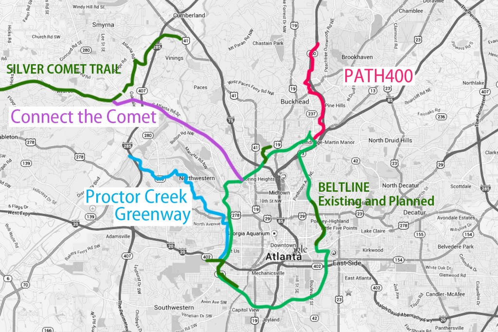
The BeltLine vision has always been about daisy-chaining communities. Turns out the original theme of connecting a loop of 45 historic intown Atlanta neighborhoods is just the beginning. As the BeltLine evolves it is becoming the central hub of a multi-county spoke-and-hub trail network.
Three significant spoke trails are in various stages of development that will connect intown Atlanta to places as far away as Anniston, AL. Here are some details on a triumvirate of unbuckled versions of the BeltLine that will link to it’s North and West sections:
- PATH400 Trail. This multi-use trail gets it’s name from the fact that it will be built within the GA 400 highway corridor. Ultimately it will be a 5.2 mile, 14 foot wide path that connects Buckhead with the BeltLine near Lindbergh MARTA Station. Construction began April 1, 2014 on the first half mile section between Lenox and Old Ivy roads. Go here for the 411.
- Connect the Comet. The Silver Comet is a country cousin to the BeltLine. Although the Comet is a 61.5 mile linear trail instead of a loop, it shares DNA with the BeltLine in that it is a rail trail, built on abandoned railroad right-of-way. It stretches east/west from Smyrna to the Alabama border where it continues on as The Chief Ladiga trail. The two combined trails make up the longest rail trail in the country. There just happens to be a section of unused CSX railroad track that goes from the current eastern-most trailhead of the Comet to a PATH trail on the east side of the Chattahoochee River at South Atlanta Road. The PATH trail will connect with the BeltLine trail in the future. Once this 3 mile connection is made, a cyclist can ride on an epic, unbroken, 100+ mile bicycle superhighway from the urban core of Atlanta, through beautiful countryside with vistas of the Appalachian foothills, to Anniston, AL. Learn more at connectthecomet.org.
- Proctor Creek Greenway. Also known as the Emerald Corridor, this 7 mile trail will follow Proctor Creek from Atlanta’s urban core through 30 Westside neighborhoods to the Chattahoochee River. The stretch will connect 6 existing and proposed parks and ultimately provide 400 + acres of greenspace. When complete, the embattled Proctor Creek will be restored to a pristine state from it’s current condition as troubled waters polluted with high levels of bacteria and toxic chemicals. This public private venture (P3) could serve as a model for gettin’ ‘er done on other sections of the BeltLine and it’s spur and spoke trails.
These projects follow the path blazed by the eastside PATH Stone Mountain Trail which connects to the BeltLine Eastside Trail. Other grassroots movements are underway to connect to points south of the city including a plan to emulate the Silver Comet on abandoned railroad corridor through Newton County.
Now all we need to do is plot a path southwest to the Chattahoochee Hill Country and it’s ambitious plan of trail network.


 ©2021 BeltLandia. All information provided is deemed reliable but is not guaranteed and should be independently verified. Properties subject to prior sale or rental.
Wonderful graphic Burke, love the visual of connectivity that is going on in Georgia!
Thanks, Tracie. The multi-talented Emily Taff did the map for me.
Great post!!
& Then there’s the trails headed east, to Stone Mountain, Arabia Mountain, & Conyers. Hopefully one day they’ll connect those, too.
If Sandy Springs continues & builds a trail northward, they could connect the PATH400 to the Chattahoochee and into Roswell’s network, connecting to the Roswell/Alpharetta Big Creek Greenway, which goes up to Windward Parkway. THEN, they are working on building another 2 mile segment to connect up to Forsyth’s trail network to Cumming. (& who knows, one day to Lake Lanier).
http://www.bigcreekgreenway.com/
http://www.forsythco.com/DeptPage.asp?DeptID=13&PageID=1355
In Rome, they are actively pursuing long-term plans to build a connector to the Silver Comet, too…
http://tredromefloyd.org/
Lastly, go to Google Maps — Atlanta & turn on Bicycling, then zoom out & you’ll see the current SOLID green lines
http://goo.gl/maps/umueg
Connect the Comet is actually a 6 mile extension: 3 miles on each side of the river- 3 miles in Cobb and 3 miles in NW Atlanta- the track is out of service all the way to Collier Rd . For those of you who know the area , the Comet could go under Moore’s Mill, over Defoors Ferry and over the Collier Rd bridge behind Hankook Taqueria. Connection options might include leaving the RR right of way at Ellsworth Industrial to tie in via bike lane to the Belt Line . There are old sidings that already do this. Another connection could be via bike lane on Collier to the Tanyard Creek Beltline trail. Ellsworth Industrial would be great place for a trail head. Caveat: all of this is just ideas of what could happen. To make something happen please sign the Connect the Comet petition; the link is at ConnecttheComet.org
Also see photos on the Connect the Comet Facebook page !
Thanks, Wendell. Our Comet Connector is definitely the more abstract of the trails depicted, given the number of alternate routes. Do hope our readers will take the time to sign the petition.
Why not add the Freedom Trail on there?