Adair Park is a relatively small neighborhood in Southwest Atlanta bounded by the MARTA line (Murphy Ave and Lee St.) on the west, Metropolitan Parkway on the east, and the abandoned railroad / soon-to-be-paved BeltLine on the south. Adair Park is a protected Historic District.
The architecture and layout is typical of an early 20th century middle class subdivision: moderate-sized bungalows, many of which are elegantly styled Craftsmans, which sit close together with driveways and long backyards. Street trees and sidewalks exist throughout. The northern portion of the neighborhood is primarily industrial and includes the The Metropolitan, former warehouses converted to “a business and arts district.”
Neighborhood association, Adair Park Today, Inc.: adairpark.com
BARS, RESTAURANTS, ENTERTAINMENT
The majority of options for dining and going out exist in the neighboring West End neighborhood and Castleberry Hills just north but
Nicky’s Seafood – at the northern end of the neighborhood has a pretty good reputation for excellent seafood.
Mustard Seed BBQ – across the street from The Metropolitan.
HISTORY
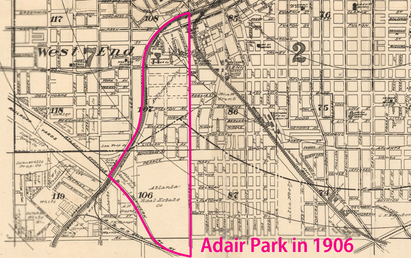
Like the West End, Adair Park’s story in the city of Atlanta dates to the Whitehall Inn, post-Civil War land speculators and the development of Atlanta’s first streetcar lines. George Washington Adair was one of those land speculators and streetcar entrepreneurs and owned a great deal of land in present-day Adair Park. However, though the West End suburb blossomed in the late 1800s, the land in the crook of the Macon & Western (later Atlanta & West Point) railroad remained mostly industrial. A 1906 map [link] shows the Atlanta Ice Co., a planing mill and a lumber company oriented to the railroad. The industrial nature of the northern part of the neighborhood remains today where I-20 cuts through.
The Candler Warehouses / The Metropolitan
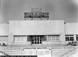
“The Metropolitan” in 1952
Prior to the turn of the century, a large plot of land was owned by another esteemed Atlantan, Anthony Murphy who is perhaps most famous for chasing down the train thieves in the Great Locomotive Chase of 1862. The parcel was never developed residentially and in the early 20th century the Candler Warehouses were built on the site. These enormous warehouses with rail spurs in between, served initially as storehouses for cotton and later other railroad storage that could be unloaded directly from train cars. The warehouses themselves featured in another historic Atlanta event, on May 21, 1917, cotton ignited at the Candler Warehouses, one of four fires which led to the Great Atlanta Fire of 1917, which raged that afternoon. The complex did not burn up, however, and today it is known as “The Metropolitan,” which leases commercial and residential space. With low rents, artists studios and businesses abound.
“Adair Park”
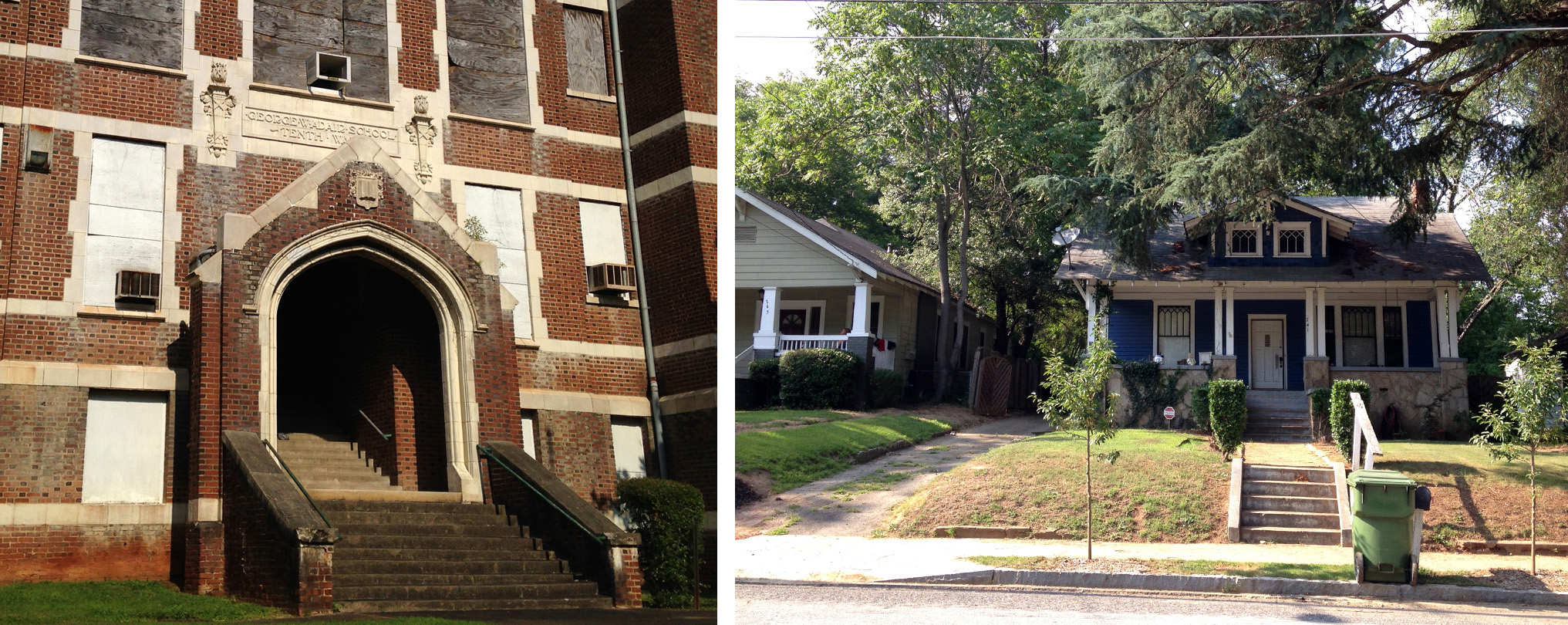
Parts of the current Adair Park neighborhood were developed in the late 1800s and early 1900s. It was not until 1910 that it was given the name of Adair Park when George W. Adair’s sons, George Adair, Jr. and Forrest Adair, began developing the remainder of the southern portion of the neighborhood as a middle class subdivision under the Atlanta Real Estate Company which their father founded. Modest bungalows remain today much as they were built, gracing picturesque tree-lined streets. The George W. Adair school was constructed in 1912 and two large parks, Adair Park I and II were constructed beginning in 1922 out of unsold lots.
Today Adair Park is a very affordable neighborhood with good neighbors both old and new. The neighborhood is within walking distance of the West End Marta station and easily accessible from any interstate in Atlanta. Signs of renewal are apparent as houses are renovated for a new century of use. Meanwhile, several historic commercial buildings and the boarded up Georgia W. Adair School are ripe for some good adaptive reuse and historic homes abound including a beautiful large turn-of-the-century house on Gillette among the bungalows waiting for someone to put some love into them.
The southern border of the neighborhood is what was once the Atlanta Knoxville and Northern Railway and is today the BeltLine right of way. Interim hiking trails have been navigable for several years and can be accessed near the intersection of Catherine St. and Allene Ave. It is also at this intersection that the BeltLine’s Urban Agriculture Site can be seen. Fruit trees, shrubs, grasses, vegetables and edible berries will provide year round public foraging so stop by if you’re hungry!
Sources:
National Park Service page on Adair Park Historic District
Wikipedia, “Adair Park”
Wikipedia, “George Adair”
Creative Loafing neighborhood article on Adair Park, c.2000
Southern Graves blog post on Anthony Murphy
Historic Maps of Atlanta online via Emory University
